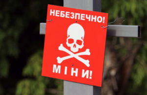
Over 130,000 square kilometers of Ukrainian territory remain dangerous due to landmines, but since the start of Russia’s invasion in 2022, over 40,000 square kilometers have already been returned to use, and nearly 10,000 square kilometers are planned for demining this year, Prime Minister Yulia Svyrydenko reported.
“Today, on International Mine Awareness Day, we note that Ukraine remains the most heavily contaminated country in the world with explosive ordnance—over 130,000 square kilometers of territory are potentially dangerous. The largest areas are in the Kharkiv, Kherson, Mykolaiv, and Donetsk regions,” she wrote in a Telegram post on Saturday.
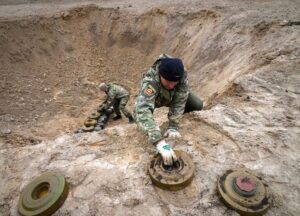
Meanwhile, the prime minister reported that since the start of the full-scale invasion, Ukraine has returned 40,700 square kilometers to use, including 15,100 hectares of agricultural land, which were cleared under the state program “Humanitarian Demining.”
According to her, Ukraine is changing its approaches to demining, reducing costs, and utilizing Ukrainian robotic systems. This year, plans are in place to return nearly 10,000 hectares to use, primarily agricultural land. The list was compiled for the first time using the GRIT prioritization system, she noted.
“We are developing the market for demining operators: their number has grown from 74 to 134, in particular thanks to the involvement of the private sector alongside the State Emergency Service and the State Specialized Service,” the Prime Minister writes.
In addition, a program is in place to compensate individuals and self-employed farmers for the cost of demining, so applications can be submitted through the State Agrarian Register.
The Soul of Soil campaign is ongoing, promoting products from demined areas and supporting humanitarian demining.
270,000 square kilometers of Ukrainian territory need demining, according to the website of the Ministry of Internal Affairs of Ukraine.
“If we talk about quantity, today we understand that it is necessary to clear about 270,000 square kilometers of mines. This includes the occupied territories,” said the head of the department Denis Monastyrsky on Friday during the All-Ukrainian telethon.
According to him, the Ministry of Internal Affairs directs the subdivisions of the State Emergency Service of Ukraine to conduct primary operational demining within a year. “In simple words, the road between settlements should be cleared of mines, the settlement, adjacent territories, as well as areas around settlements should be completely cleared of mines. But complete demining, which includes roads, forest belts, reservoirs, will take years,” Monastyrsky stressed.
As for relaxing on the beaches, the minister warned that swimming in most reservoirs in the Kyiv, Kharkiv, Sumy and Chernihiv regions is dangerous due to the presence of explosive devices. According to him, local authorities independently determine whether it is possible to swim in certain reservoirs. He also stressed that the study of reservoirs requires special professional equipment, which is scarce in Ukraine, and urged Ukrainians not to visit reservoirs yet because of mine danger.
“We turned to our international partners-colleagues from the European Union. They will help us both with teams that will come from abroad and directly with the equipment for such demining,” Monastyrsky said.
The State Service of Ukraine for Geodesy, Cartography and Cadastre has announced a tender to carry out aerial mapping of the territory of Ukraine, as well as to create orthophotomaps and a digital terrain model (DTM), Ukrainian Prime Minister Oleksiy Honcharuk has said. “Ukraine will have high-quality and accurate 3D models of forests, industrial structures, as well as classifications of buildings, plants, power lines and much more. Investors will be able to easily design facilities and invest in infrastructure,” the government’s press service reported, citing Honcharuk as saying. According to the report, the total cost of the work is UAH 276 million. The deadline is until December 2020.
In addition, in preparation for land reform, the State Service for Geodesy, Cartography and Cadastre is actively filling out a database. So, in three months, six new information layers appeared on the public cadastral map. Now information on 20.9 million land plots (total area of 43.8 million hectares) has been entered.
Among other things, the authority began using satellite-based land monitoring data in test mode, and in just a week completed 755 public control measures over the use and protection of land.
It is reported that according to the results, 301 violations of land legislation with a volume of damage of more than UAH 1 million were revealed, of which UAH 691,720 were voluntarily repaid.